Papua New Guinea
Common Country Assessment

2022 Environment-Climate Analysis

Papua New Guinea (PNG) has outstanding natural wealth, an exceptional diversity of wildlife and a growing population, most of whom live subsistence lifestyles and depend directly on the environment to provide their daily needs.

However, PNG's natural resources are being depleted rapidly, with impacts on both biodiversity and people's well-being.

This environment and climate analysis, a summary of the PNG Common Country Analysis report, collects and analyses information, examines progress, programmes and gaps, and makes recommendations about environmental topics including vulnerability to disaster, and the environmental factors relating to the people left behind.

Environment

PNG lies in the southwestern Pacific Ocean and comprises the eastern half of the world's second largest island of New Guinea and about 600 small islands. Today it comprises 21 provinces.

Highest point
Mountain icon
4,509m (asl)
Volcanoes
Volcano icon
47
Exclusive Economic Zone
EEZ icon
1.7m km2
Provinces
Provinces icon
21
Main exports
Metals icon
Metals
Coffee icon
Coffee
Cocoa icon
Cocoa
Fish icon
Fish
Wood icon
Wood
Population (2020)
Population icon
8,947,027
Land area
Population icon
452,860km2

The island of New Guinea's geography is defined by the central high Bismarck mountain range, including the highest mountains in Oceania, with several smaller coastal ranges stretching towards the coastline (see: Digital Elevation Model). Part of the Pacific Rim of Fire, a line of volcanoes stretches along the north coast of the mainland and several of the islands are active or recently active volcanoes (see: Volcanic eruptions).

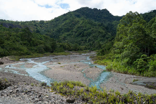
The high equatorial ranges and warm tropical seas generate high rainfall, which feed thousands of streams and rivers that have broken the landscape into many isolated and hard-to-reach plains and valleys (see: Rivers Flood Frequency for a visualization of the stretch of watersheds and their flood potential). To the north and south of the central mountain range lie vast stretches of mangroves and wetlands including the Sepik River, which is the longest river system in Papua New Guinea. Coral reefs and seagrass meadows fringe the islands and coastline, and Papua New Guinea's waters are estimated to hold the highest marine biodiversity in the Pacific.

Papua New Guinea's Environment

Select a layer
?
Digital
elevation model
legend

The above map sets the context for Papua New Guinea's rich and remote geography, including its high mountains, vast river system, and high level of endemic and threatened biodiversity. The implications of this geography include:

  • Evolution of very diverse flora and fauna, including many endemic species - those found nowhere else in the world - see Range Size Rarity of all 1184 forest-based mammals, birds, reptiles and amphibian species native to PNG, as defined by the IUCN Red List of Threatened Species (2017).
  • A high dependence on natural resources for lives and livelihoods, with over 85% of Papua New Guineans dependent on natural resources for subsistence, and the national government heavily dependent on extractives as a source of income.
  • Poor accessibility to remote communities and the development of diverse cultures with over 850 recognised languages. This remoteness has been compounded by a lack of infrastructure and services and high transport costs in many areas.
  • High vulnerability to volcanic eruptions, earthquakes and other natural disasters and the impacts of climate change.

Biodiversity and Conservation

A biodiversity hotspot under threat

Papua New Guinea makes up a tiny portion of the world's land mass...
But contains a disproportionately high percentage of its biodiversity.
MARINE FISH 2584 species BIRDS 740 species MAMMALS 298 species AMPHIBIANS 342 species REPTILES 333 species BUTTERFLIES 924 species FRESH WATER FISH 337 species 3.3% 4.6% 7.7% 5.3% 17% 5.5% 2.2% PNG LAND MASSGLOBAL LAND MASS 1% % OF GLOBAL TOTAL SPECIES FOUND IN PAPUA NEW GUINEA
Papua New Guinea is home to a large number of endemic species, meaning they do not exist anywhere else in the world.
BONY FISHMAMMALSSHARKSAND RAYSREPTILESANTHOZOABIRDSINSECTSFROGS 4% ENDEMIC 2 358 29% ENDEMIC 294 9% ENDEMIC 112 35% ENDEMIC 34738 15% ENDEMIC 741 43% ENDEMIC 402 81% ENDEMIC 362 Approximate number of species
1
Due to small populations and niche habitats, these species are extremely vulnerable and must be protected from extinction.
The number of vulnerable, endangered   and critically endangered plant and animals species is rising. 2
Plants
Animals

It is essential to conserve Papua New Guinea's wild areas to prevent the extinction of thousands of species and preserve global biodiversity

Threats to wildlife and biodiversity include wildlife trade, unsustainable hunting and resource use, invasive species, clearing and habitat loss, loss of biocultural knowledge, climate change, and pollution and sedimentation.

Sustainable use of wildlife is a pillar of survival for many rural people in PNG, as a source of food, medicine, firewood, and building materials. Wildlife is also an integral part of the cultural and traditional life. Sustainability has become more difficult to ensure due to increasing human populations placing pressure on habitats for wildlife populations. The people who suffer most from biodiversity decline are the poorest, who are reliant on hunting and fishing for survival, and women and children.

Natural resource management for sustainable lives and livelihoods

The UN and development partners support a number of programs to improve biodiversity outcomes through strengthening management effectiveness, establishing a network for community collaboration and partnerships, advocacy initiatives to create a forum for conservation stakeholder, piloting demonstration initiatives and sustainable financing. One important output has been the creation of a toolkit of resources for stakeholders working in Papua New Guinea to establish, manage, and monitor protected areas, www.PNGBiodiversity.org.

Protected Areas

In 2022, there were 61 formally gazetted protected areas in Papua New Guinea totalling just over 2.2 million ha (4.8 percent of the land area), well below the globally agreed 17% for terrestrial protected areas as stated in the Convention on Biological Diversity Aichi targets.

Representation of protected ecosystems and species falls well short of the agreed targets - only 4% of the Key Biodiversity Areas in Papua New Guinea are officially protected. Priority areas for future reservation have been identified 3 , but the resources required to create new protected areas is significant. This includes free, prior, and informed consent of landowners during the protected area proposal process.

Papua New Guinea's Protected Areas

Protected Area Type
Legally gazetted
Proposed
Source: Drawn from data from protected area database, provided by CEPA, Government of PNG

Protected and conserved areas offer opportunities for PNG communities, as they can be a focus for funding that integrates conservation objectives with social and economic progress and the continuation of diverse cultures.

Tools have been developed to help stakeholders assess, establish, and monitor protected areas. One of these is the localized Management Effectiveness Tracking Tool (METT). You can read more about the process of developing the PNG-METT and where to download additional resources at the “METT Case Study”.

A long-term, sustained effort needs to continue at many levels to support protected areas - including in remote locations. With the support of UNDP, a national Biodiversity and Climate Fund is being established as a legally independent institution which will aim to support financial sustainability of protected area management in the country, as well as support the coordination of fund-raising efforts on behalf of protected areas.

Forests

Papua New Guinea is one of the most densely forested countries in the world, with forest covering an estimated 78 percent of the total landmass 4 .

In terms of ecosystem structure and function, carbon storage, and biodiversity, these forests are globally significant. Most forest land is owned by customary landowners who rely on forest resources for subsistence and income.

About 76 percent of forests have had no significant human disturbance. Nearly 11 percent are logged, and around 13 percent are disturbed by other activities -- namely subsistence gardening, fire and small-scale logging, such as wokabaut (mobile) sawmills. Logging activities mainly occur in low altitude (<500m) forest on plains, fans, and uplands that are easily reachable from villages 5 .

Land Use & Deforestation

Deforestation
Land use
Satellite
Deforestation (2000 - 2020)
Loss
Land use
Map legend

Shifting agriculture is reported to be the most significant driver of deforestation (responsible for over about two thirds), followed by oil palm plantation development 6 and logging.

Key areas of concern related to forestry include: impact of timber harvesting activities, including sustainable logging cycles and illegal logging; third parties' rights; transport and trade; and poor governance, including lack of suitable engagement with customary landowners. PNG is the largest exporter of tropical round logs in the world, exporting 84% of these logs to China. 8

Climate Change

Global climate model projections indicate that for PNG in the coming century: 9

Annual mean temperatures and extremely high daily temperatures will continue to rise;
Average rainfall is projected to increase in most areas, along with more extreme rain events;
Droughts are projected to decline in frequency; and
Sea level will continue to rise.

Coral bleaching hotspots

Coral bleaching
hot spots
legend
0℃
This map is a daily livestream of high risk coral bleaching hotspots globally. As we can see, Papua New Guinea is already under threat.

For coastal people, the projected effects on the marine environment are concerning. In addition to ocean acidification, coral bleaching from higher temperatures is expected to become more severe. 10 The loss of coral reefs would be devastating for many coastal communities, where people depend on marine life for their daily subsistence as well as for income. Inland and coastal flooding increases sedimentation entering river systems, particularly from areas where forest clearing has led to increased soil erosion. The extra mud and silt runoff can kill coral reefs and damage other vital coastal ecosystems for sequestering carbon and protecting biodiversity, seagrass meadows and mangroves. Loss of these marine systems would mean the natural barriers to waves and winds disappear and the effects of severe weather events are exacerbated.

The vast natural forests of PNG play an important role in regulating climate, and PNG was traditionally a carbon sink. However, by 2015, PNG had become a net source of carbon, as a result of accelerated land clearing and land use change and increases in emissions from the energy sector.

As seen in the below graph, net emissions returned to below zero in 2017 as the rate of forest clearing and logging decreased, but emissions from energy sources have continued to increase.

Adaptation and building resilience is also a focus for the government and development partners, as impacts from climate change increase. An implementation plan for the Nationally Determined Contributions to the Paris Agreement was published in in 2021, and roadmaps for the Agriculture, Forestry, and Other Land Use (AFOLU) and the electricity sectors have also been developed. 11 PNG will submit its National Adaptation Plan (NAP) to climate change to the UNFCCC in 2022.

Many organisations are supporting PNG in meeting its climate commitments and to help its people adapt the climate challenges. UNDP is a key development partner, along with other UN and intergovernmental agencies; governments, including Australia, USA and New Zealand, the European Union and its member states; and a number of NGOs and other institutions. The 2022 Biennial Update Report lists 26 partner projects and estimates that more than USD 1 billion will be needed over the next 10 years to achieve the Enhanced NDC targets. 12

Vulnerability to natural and environmental disasters

PNG is among the most disaster-prone countries in the world. Prevalent hazards include earthquakes, cyclones, storms, volcanic eruptions, riverine and coastal flooding, coastal erosion, tsunamis, epidemics, and droughts. 13

Climate-related hazards are expected to become increasingly severe as a result of climate change (e.g. droughts, sea level rise). The INFORM Risk Index (2022) ranked PNG as the 22nd most vulnerable of 189 countries in relation to hazard and exposure, vulnerability, and lack of coping capacity.

Multi Hazards Mortality Risk

Risk
Low
Moderate
Medium
High
Extreme
This dataset includes an estimate of the global risk induced by multiple hazards (tropical cyclone, flood and landslide induced by precipitations). Unit is estimated risk index from 1 (low) to 5 (extreme).

Natural and environmental disasters particularly affect the most vulnerable in the community, including children, women, the elderly, people living with disability and the rural poor. Gender-based violence after disasters has been reported widely.

Hazards which require adaptive measures 14

Hazards and Risk Exposure
Coastal Flooding
  • Climate change will exacerbate the issue due to rising sea levels and occurence of coastal storms
  • Damages infrastructure
  • Affects ~6,000 and displaces ~400, several deaths on an annual basis
Inland Flooding
  • Occurs multiple times per year
  • Damages buildings and infrastructure
  • Affects ~26,000 annually, including the displacement of ~8,000 people and several deaths.
Land Slides
  • Affects 500-600 and kills several people in remote, mountainous areas
  • Damages infrastructure, particularly roads, causing transport issues
Malaria
  • Already affects half of the population, with climate change impacting ~200k more in the Highlands as conditions become more tolerable for the disease
  • Highlands cases are becoming more severe
Agricultural yield loss
  • 3 million people depend on climate-sensitive crops
  • Climate change may reduce yields: adaptation measures are needed
Coral reef decay
  • 70,000 people earn a living from reefs
  • Bleaching events and decay will reduce the livelihood and subsistence opportunities

Investment in disaster planning, response and recovery is largely funded from external development assistance. UNDP and other development partners continue to fund activities that aim to strengthen disaster prevention, response and recovery including expanding early warning systems, and local area preparedness, response and recovery.

Those left behind

The primary identified risks to biodiversity and the environment all have additional impacts on people and communities. Women and other 'left behind' groups in PNG tend to suffer most from environmental disasters and decline.

About 87 percent of Papua New Guinea's population live in peri-urban, rural and remote settlements, and 80 percent rely on artisanal fishing, hunting, gathering and gardening for livelihoods and subsistences. 15 There is little cash flow and limited access to health care, education, sanitation and clean water. 16 40 percent of Papua New Guineans live below the international poverty line. 17

Rural and remote communities are vulnerable to shocks resulting from extractive industries, especially where people are largely dependent on the local environment for their livelihoods.

The riverine tailings from the Panguna mine in the Autonomous Region of Bougainville has caused permanent damage to the Jaba River system, 30 years after the mine's closure.
img

The remoteness of many of PNG's rural communities can create immense challenges for responding to disasters effectively, and lack of local infrastructure and health services can have long-lasting impacts on communities following catastrophic events. 18

Climate change is already affecting the most disadvantaged and will result in many more people being 'left behind' unless actions are taken. Women and children suffer most adversely, and it was reported that “women…(are) often most vocal about dimensions of vulnerability (e.g. population growth) and their links to social issues (e.g. alcoholism, domestic violence and petty crime) that they viewed as likely to be heightened through ecosystem decline”. 19

Multidimensional risks

Clearing and habitat loss
Unsustainable extractive industries
Unsustainable resource use and Wildlife trade
Invasive species
Loss of biocultural knowledge
Pollution from mining, waste disposal, plantations and industry
Climate change
Areas affected
  • Biodiversity
  • Climate change (loss of carbon sink)
  • Clean water (loss of portected catchments, sedimentation)
  • Food security (soil erosion, loss of forest resources, fish catch)
  • Disasters (increased likelihood of landslides, floods, famine, fires)
  • Increased conflict and women most affected
SDGs impacted
The risks to environment and climate in Papua New Guinea cause cascading effects throughout natural and human systems. This chart demonstrates how the progress of the Sustainable Development Goals might be impacted by environmental risks.

Recommendations

Recommendation for improving environmental management and governance can be grouped into seven headings:

  • Finalise the Protected Area Bill and its regulations.
  • Modernise biodiversity legislation and policies, including instruments to conserve threatened species, to participate in the Nagoya Protocol, and to formalise an offset hierarchy (avoid environmental damage, mitigate or offset).
  • Review the Environment Act 2000 and strengthen where necessary, including a requirement for independent bodies to oversee and report on how industry meets environmental permits and regulations, rather than relying on industry self-regulation.
  • Require tailings and other mining waste to be contained and managed, rather than dispersed to the environment, for all new mines or extensions of existing conditions.
  • Require stronger environmental impact studies and conditions, and effectively monitor and enforce environmental conditions in all extractive industries, including mining, plantation development and management, and forestry.
  • Support implementation of the ban on round log exports by 2025.
  • Implement the National Sustainable Land Use Policy, ensuring that it reflects the needs of customary landowners and protects their rights to land and sea and ensures women's land rights are improved and made more secure.
  • Identify areas where development should be constrained due to high biodiversity or cultural values or climate vulnerability and use simple decision support tools at the local level to gather essential information to inform land and sea use planning and delineate zones with specific values and uses.
  • Upscale and integrate land and sea use plans developed at the local level into provincial land use plans.
  • Employ and support environment staff at national and provincial levels, including for biodiversity and protected area management.. Ensure high degree of transparency, accountability and anti-corruption measures for jobs related to aspects such as environmental approvals, forest operations and wildlife trade.
  • Support PNG's national NGOs and CBOs working for environmental and social benefits, including capacity development for local protected area management committees.
  • Develop a network of community and protected area rangers to undertake a range of tasks in rural areas: enforcement of protected area and biodiversity laws; invasive species control; maintenance of community and tourist facilities; environmental education and monitoring and maintaining clean water and waste systems.
  • Assist communities to have a full understanding of the implications of development proposals and their likely expansion in order to provide or deny informed consent. Ensure women and vulnerable groups are equally represented in the process.
  • Implement benefit sharing agreements and livelihood support for conservation-related initiatives including payment for ecosystem services (PES), incorporation of ecosystem services into national and subnational accounting, livelihood projects, ecotourism and research payments and benefit-sharing agreements.This should include blue carbon options and the sustainable blue economy.
  • Plan for future migration and increased mobility into rural and urban areas, likely to result from mining, oil and gas exploration and extraction, forest operations, other industry, natural disasters and climate-change related issues such as sea level rise.
  • Strengthen, resource and expand programs that address both ‘those left behind’ and environmental matters.
  • Manage species sustainably and develop species management plans where needed.
  • Reduce emissions from LULUCF sector by effectively implementing the national REDD+ Strategy 2017-2027 and reducing the impacts of commercial logging, subsistence agriculture and oil palm plantations.
  • Support tradition, tambu systems and local practices for sustainable management.
  • Increase wildlife conservation awareness programs.
  • Improve partnerships in protected area management.

UN agencies can support and assist the government, where relevant, and can further promote policies and actions toward achieving the SDGs.

Resources